
Compendium Four
Technology: tools, workflows and processes used in design
August 2026
Processing
Over years of practice and academics, I've learnt to create across several workflows, integrating data, visual media, and design. I use tools recursively to prototype, infer site data, and drive design processes. While I've worked largely with visual media, I also use a series of tools to extract and manipulate data or text as alternate media to create.

This compendium contains tools, projects and processes where I've used various kinds of technology and alogorithms to prototype, learn, or create content.
"Sky Eyes", for example, is a visual project which uses outputs from various tools I've created, using satellite data, recursive AI workflows and agentic conversations.
Artificial Intelligence
Model Ecology
An AI-Enabled App to Simulate ecological succession in Landscapes
(In Beta Testing)
Tools can be built easily with generated code. While not particularly "Ship"-ready, these tools can be used for a series of inferential as practical tasks.
This tool started as an exploration of trophic systems in ecology, attempting to understand how a landscape may evolve over time given a certain set of starting species, terrain, and a specific ecological spread algorithm based on real-world simulation models.


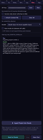


Click each panel to enlarge
A series of screenshots showing the various functionalities of the tool, from terrain analysis to species population, simulation algorithms, Claude API integration, and cellular metadata.

3D terrain corresponding to the placement of the cells exported out of the script. (Created using ModelEcology, ArcGIS, Rhino and Grasshopper)
Reality Capture
Gaussian Splat Editor
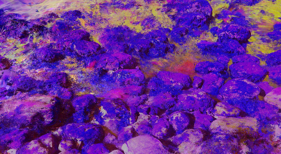
Still from a recolored Gaussian splat created using Claude within the Gaussian Splatting tool. (Palos Verdes, California, capture by Kahin Vasi)
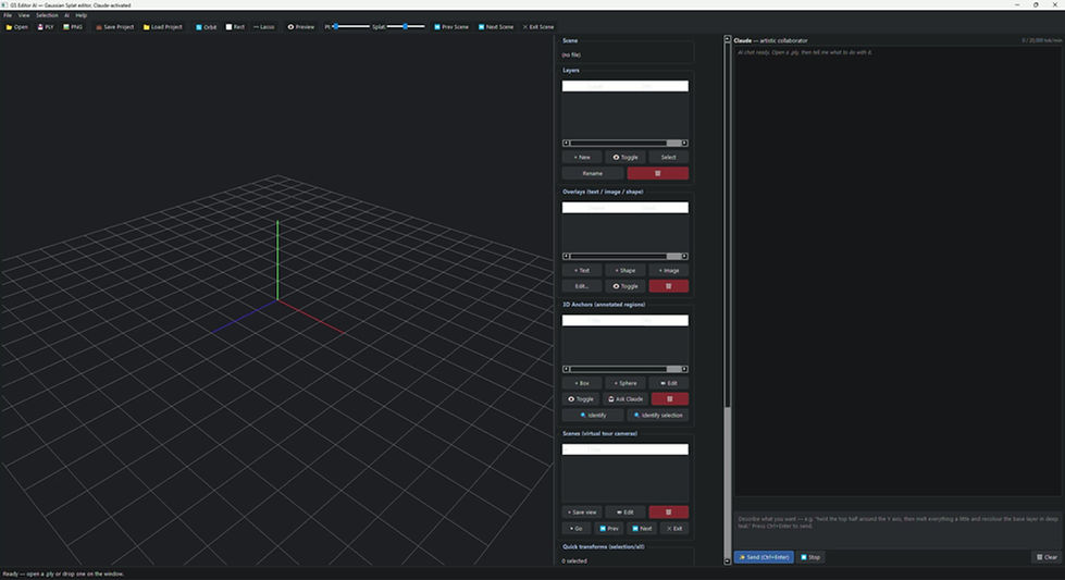
Demonstration of the Gaussian Splat application: Using Claude to identify, detail and create virtual "tours" of the gaussian splat
What role does modern technology play in the way we interact with nature? Can virtual reality be more than pure reality? Can we layer spectrums, data, information and inferences onto a singular virtual landscape?

Python code built with Claude, allows Claude to analyse Gaussian splats and pointclouds and layer information from the internet onto the Gaussian splat, used as an education tool (Created using Claude Code and Python)
This project is part of a collaborative proposal, with Gaurav Patil, a Marine Biologist and Photographer Based in Mumbai.
We're exploring tidepools as a medium to render real landscapes into "invisual" or technical images. We're doing this through 3D scans, photogrammetry, and gaussian splatting. In particular, we're exploring how these spaces can be made more accessible to people without the ability to visit tidepools, and how we can augment virtual models with biological data and multispectral imagery

Multispectral imaging of the Palos Verdes intertidal zone, where algae and seaweed appear "purple".

Still from a 3D Gaussian Splat created using NDVI images. (Palos Verdes, California, capture by Kahin Vasi)
Creative Code
Map Splicer

A 3D terrain model exported into Rhino using the "Mapblend" code, textured with the spliced color layer. (Created using Rhino,

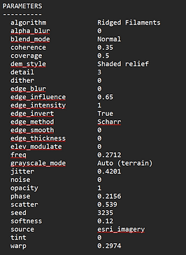
Mapblend uses open-source basemaps and geolocation information (Esri, USGS, OpenStreetMaps) to draw satellite and terrain data into the program, and then splices images into the active map using edge detection frameworks and algorithmic spatial distributions.
Each image extracted comes with license and algorithm data which can be ingested to recreate a map; it is also possible to use the spliced pixels to modulate the terrain data locally, using the basemap.
Satellite images are some of the most aesthetically interesting media to work with; this blender combines the imagery with a locally derived layer, leading to an emergent aesthetic.

Sky Eyes: An AI Agent Panel Discussion
Sky-Eyes explores the potential for the creation of informational and documentary-style content using AI and creative coding. All satellite images are rendered out of "Mapblend", and the
Project: Synthetic Landscapes
The Unreal and the Real (2025)
This project experiments with multi-agent chat interfaces using Xforce, RAG and python to run multi-agent chats natively.
The video below was created through a recursive process of switching between generative media and real world.

AI Agents Talk.
Their Words Are Dissected into Prompts.
Prompts are used to create images.
Images train styles.
Styles Create Miniature Worlds.
Miniature Worlds are 3D Printed.
3D Printed Worlds are Scanned.
3D scans are rendered into alien landscapes.
Is this how AI Agents imagine real worlds?

Agentic conversation from Xforce with a GUI. They're asked to imagine deep time futures.

Each character's dialogue coalesced into a prompt, used in Midjourney V6 to create abstractions.

Abstractions from Midjourney used to create "Tiny Worlds" with Fuser, which are then applied to various base images to generate iterations of plants


Tiny planets from Fuser.

3D printing the tiny planets as half-sunk in a miniature zen garden (or is it a massive zen garden with several planets within it?

3D printing the tiny planets as half-sunk in a miniature zen garden (or is it a massive zen garden with several planets within it?
Artificial Intelligence
Multi-Agent Chat
Claude-based Multi-Agent Chat Interface for Creating Agents and using Large Document Contexts
(In Beta Testing)
This tool arose from limitations I found with working with older agent chat platforms used (such as xForce), which limited the output in certain ways. Most importantly, I wanted to be able to use real-world research and data to augment the conversations happening in these "chats".
This program is created specifically to create extremely realistic an informational chats; you can set up multiple Agents with several context files, choose their disposition and response types (qualitative, quantitative, synthesizing, etc). Most importantly, massive contexts and multiple context files for each agent to draw from can be optimized to reduce the amount of tokens required to work. The optimization streamlines the context document and synthesizes it into agent-available information prior to the actual "chat".

Demonstration of the Agent Set-up, document optimization and chat interface workflow within the application.
Algorithm
Circle-Packing Tool (2025)
This was a tool created for use specifically with figure-ground (negative space) plans in order to randomize circle-packing on a site as a design prompt. Based of variables, including density, size, and spawn points, the algorithm generated clusters of tangentially associated structures which could be exported into DXFs.

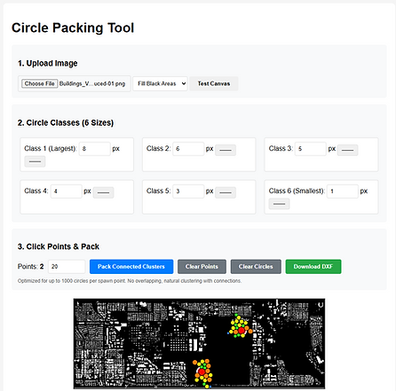
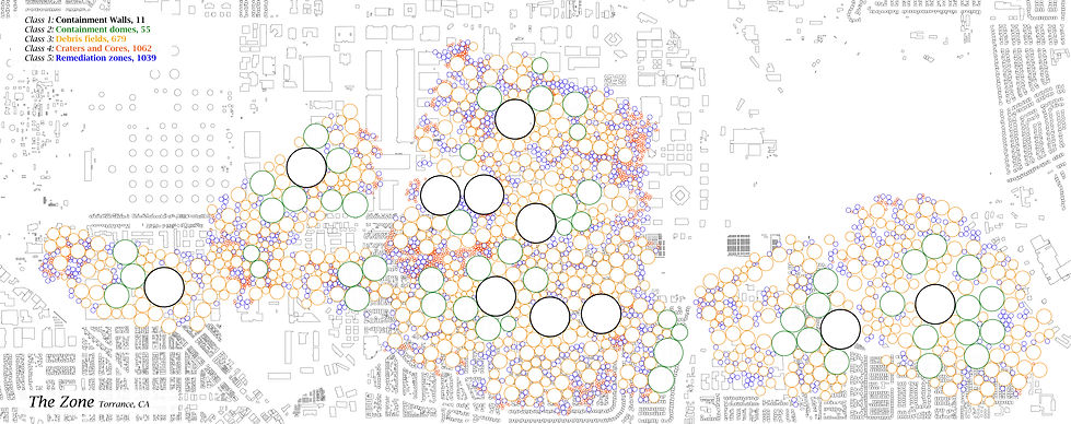
Using the "circle-packing" algorithm above to decimate the superfund site: a meso-scale "field of toxic blooms", rendered into a series of structures, craters, debris fields, and remediation zones; categorized by scale. (This image was created using ArcGIS, python in Claude Code, and Rhino)
Project: Synthetic Landscapes
The Zone: Chimeras in Superfundland (2025)
Capstone project for the Synthetic Landscapes Program at SCI-Arc
How do we face extreme toxicity?
How do we stir ecological emergence into exceedingly uninhabitable sites?
Using algorithmic frameworks and containment structures around a toxic chemical plant designated a "superfund" site.
An essay about this project was published in Ecological Design Collective's publication "Litter: Antidotes to Toxicity" in 2026. To read more, click the link below.

Imagining elements of "The Zone": Generated orthophotos (mimicking satellite or aerial photographs) of each Class of structure within the zone. These images were created using a recursive process, using Midjourney V7, Rhino, Midjourney Retexture, and Photoshop.

Base structure modelled using parametric tools on Rhino

Midjourney V7 used to retexture the model

Photoshop used to post-process the retextured model


Snippet of a dark "PPE-themed fashion advertisement" associated with living and culture within The Zone: inhabitants, forced to don hazmat suits, contract award-winning fashion designers to create an aesthetic hazmat line. Generated using Fuser with Fal Flux Dev, Kling Video, Wan based on database documentation and Claude prompts
Project: Synthetic Landscapes
Disturbed (2025)
Disturb:
To agitate, to mix, to break up.
This project is based in Central Valley, CA.
How do you agitate farmland into a wetland ecosystem?
The speculative future of the farm; a bird's eye view.

Langer Farms, Central Valley, in 2025, satellite imagery


Future evolution of Langer Farms, from a dryland ecosystem to a water mixing facility. Created using QGIS, Midjourney v6, and Photoshop
Surfaces and Volumes
Bruno Latour's essay around the Actor Network Theory (ANT) talks about the "rhizome" as a replacement for a planar Cartesian surface, where, rather than subdividing land by area (a surface metric) we can study ecologies in terms of interaction networks (rhizome). To create these interactions between water and organisms, I render the farmland into a series of volumes within which these interactions take place.
The Cartesian grid is subdivided into units, each a power of -2 under the 1 mile Cartesian unit.
Cultures of bacteria, archaea, protozoans are "introduced" to the farm runoff, forming microbial trophic pyramids which "use up" the excess nutrients in the water. These trophic systems also bring in macro-faunal species such as migrating birds, mammals and amphibians to this pseudo-oasis within the Central Valley.


A longer evolution of Langer Farms, from a water mixing facility to a riparian ecosystem. Created using QGIS, Midjourney v6, and Photoshop

The process for creating these satellite images involves creating training data of various ecosystems through GIS images, combining and generating initial images, and collaging multiple images on the base image.

Point Cloud Manipulation
Using generated scripts to edit LiDAR and photogrammetry data
The point cloud editor (originally, point-cloud flattener) indexes millions of points from LiDAR or photogrammetric scans and uses mathematical vectors to edit the points, by "decimating" or "flattening" the points, or adding numeric noise to the X, Y, and Z values of the points.
This was used to create LiDAR elevations (like the one seen above) as a part of the Altadena Scans Project

Project: Synthetic Landscapes
The Microcosm
Created in collaboration with Marti Vera Marsal, Ahmed Yakout, and Rudy Argote.
Part of the Synthetic Ecologies Seminar, Synthetic Landscapes.
The creation of a microcosm to study new ecological concepts.
This "terrarium" is a synthetic water body. The intent is to introduce microbes and algal cultures, documenting how the water changes through a timelapse recording of the terrarium over various stages of introductions, disturbances, and simulated ecological shocks.


Organic deposits line the 3D-printed "introduction" apparatus, a truncated pyramid. Zoom in to see the details.
Between February and September 2025, this experiment ran (chaotically) with various "introductions" - each introduction leaving a trail or depositional layer of organic detritus in it's wake.

Representation of the microcosm: I used a "systems diagram" over time to map the various inputs, outputs, and conditions of the microcosm. This accounts for all the mechanical, static, environmental, and biotic components of the microcosm. (Authored by Kahin Vasi)


Samples of the detritus deposits in the microcosm show the presence of nematodes, various species of cyanobacteria and filamentous algae, fungal hyphae, paramecium and other zootrophic multicellular organisms. The cyanobacteria culture (pictured top centre) was developed from a water filter sample.
Our "aesthetic" sensibilities towards nature come from a notion of control; using chemical baths and additives to stem the growth of algae and fungi.
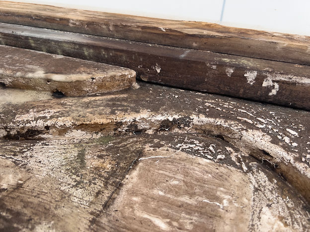
This experiment embraces the descent into ecological entropy as every element of the base breaks down and is layered with a crust of detritus.

When the terrarium dried out completely (this process can be seen towards the end of the timelapse), it left behind a crust of organic matter of the surface of the base, which - although coated with a white waterproof epoxy - soon became the substrate for fungal growth.
Experiments
Microhabitats
I created terrariums, aquariums, and microhabitats professionally for five years, something I still practice as a hobby today.
Gradually, my work on creating biotically sound enclosures (replete with flora and microfauna) slowly turned into a series of long-term experiments, studying the decay of organic matter over long time periods. This expanded to fungi and algae habitats, as well as a habitat dedicated to observing slime molds.
Rotting Wood For Detritivores (2026)


The Slime Mold Microhabitat (2024)

The slime mold habitat: slime mold was found on a branch from a site visit in 2024; this is the central branch (with visible mushrooms). The culture spread onto a wet paper towel which was used to transfer the slime mold to it's habitat.


The slime mold can be seen growing across various surfaces; all surfaces were sprayed with a bacteria-rich biofilm from aquariums, making it easier for the physarum to colonize the surfaces. The structure of the slime mold growth is visible clearly as it extends up the surface of the habitat.
Detritivore Microhabitats (2019 - 2025, ongoing)


Documenting cycles of decay in a detritivore microhabitat with wild isopods (species from India), recording the daily progression of the decomposition of shredded carrots as feed stock. These cycles were recorded near continuously for over a year.


Isopods in various colonies, with a variety of climate conditions. (note: all isopods are stored in specially modified containers to ensure proper air flow, moisture, and colonies are split or released if the population within a colony gets too large)
These experiments often form the basis of several prompts or image generations, including as parts of training data where I want to explore the aesthetic of rot, decay, and subterranean networks.

Microscopy & Imaging
A second source of interesting visual media includes microscopic images (as with the rotifer in the video above). Over the years, I've built up a library of microscopic observations, more recently high-resolution sharp-focus photographs, which I would like to use to drive image generations within AI workflows.


Experiments
Image Manipulations
Working with digital tools in two- and three-dimensional spaces has lead me to develop novel ways of interacting with these media.
I've used AI to develop code which can manipulate images and 3D models by indexing and recognizing values of each unit - a pixel, point, or splat, allowing me to recompose each set as a generated or transformed collage, or simply to manipulate the location of the individual units.
Pixel Manipulations


Examples of images created using base data sets of satellite images, IR photography, Multispectral Photography, and photographs. Pixels are manipulated using Python scripts created iteratively using AI.


Using python code with built-in edge-detection algorithms, I can manipulate base images of Bayan Obo Mine (lower left) and Deonar Dumping Grounds (lower right).


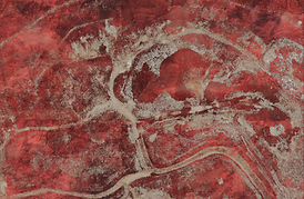


The script automatically creates a series of images using pixels which have been manipulated through various spatial mathematical algrorithms

Another python code created with AI indexes "strips" of pixels within photographs, and stitches them in sequences defined by similar mathematical, spatial algorithms


The generated images are then used in a further generative process by training styles or models in Fuser, ComfyUI, or Midjourney to create pseudo-real images.


Images created using the pixel-blend algorithm with Satellite images + multispectral imagery as datasets
Base datasets
Creating imagery with open/general use models like Midjourney or Flux relies on open, generalized datasets such as LAION-400MILLION. More recent versions of Midjourney cannibalize images from their own generations. This creates an aesthetic I don't quite like.
One of my early processes included building novel datasets, or image "references", which can drive my generations in a particular aesthetic direction. Using images with multispectral or hyperspectral baselines can create lead to interesting visual generations.
I generally use MIDJOURNEY to generate quick tests which are fine-tuned through moodboards and styles. These "primary" generations are then used to train a LoRA or within ComfyUI and Fuser as a base image.
Multispectral Imagery


Testing image generations using the raw, processed Red/Green/NIR base image (using Midjourney v7)
IR Filter Photography


I use a 720 nanometer Infrared filter and a DSLR to create specialized photographs, which I then use to train a style or LoRA.


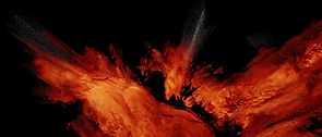


Test generations with multiple image sets including satellite imagery + IR Photography. (Using Midjourney v7)
The image generation process undergoes several iterations.
For every twenty images, one may be ideal.
This is combined with other ideal images to train a style or LoRA.
The resultant images from the style generations (with specific prompts) are used as a reference or retexture.
Finally, multiple images are collaged into a single canvas.
